

Introduction
History
Organization
Tax Abatements
Commissioner Meetings
Maint/Channel Projects
Elections
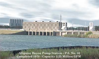
Photos
Downloads: Maps/Forms
Links of Interest
Drainage District Map
Utility Consumption
Special Notices
Hurricane Information
Hurricane Track Map
Contact
Disclaimer

Introduction
Jefferson County Drainage District No. 7 (DD7) is one of three Drainage Districts located within Jefferson County, Texas. DD7 was established as a political subdivision of the State of Texas in 1946 and serves the drainage needs of South Jefferson County.
The District covers an area of 107.42 square miles and encompasses the cities of Port Arthur, Groves, Nederland and Port Neches and unincorporated areas of Jefferson County. Two thirds of the District is below five (5) feet above sea level. Sixty (60) to Seventy (70) percent of the District drains to Taylor's Bayou. Rainfall for this area averages 53 inches per year.
In 1962, as a joint venture between DD7 and the U.S. Army Corps of Engineers, a Hurricane Flood Protection System was incorporated into the District at a cost of $84 million; the District paid 30% of the cost, U.S. Government 70%.
At present 281 miles of concrete and earthen outfall ditches, 36 miles of levee and seawalls, and 20 Pump Stations serve the District with a combined pumping capacity of 8.2 million gallons per minute.